 Live Music Archive
 Librivox Free Audio
 Metropolitan Museum
 Cleveland Museum of Art
 Internet Arcade
 Console Living Room
 Books to Borrow
 Open Library
 TV News
 Understanding 9/11
tv NBC Nightly News NBC October 19, 2012 6:30pm-7:00pm EDT
6:30 pm

join me in voting for question 6. on the broadcast tonight, 18 days and one last critical debate to go now. tonight, there is a new word in the political dictionary. and what happened last night that a lot of americans wish we could see more of. disappearing act, remember the uproar over the x-ray full body scanners over at the airport. why many of them have started to disappear from some of the nation's busier airports. and signs of hope tonight, from malala yousufzai, the young woman targeted for assassination by the taliban, for speaking freely, tonight there is remarkable news from her hospital room. and having babies, news about women and having babies, with science.
6:37 pm
circled here. you want to be taking shelter. folks on the other side of -- eastern part of baltimore county -- be on the lookout in these locations. they will be on the you within the half hour. >> we can hear heavy rain. we have a meteorologist on the phone. where are you exactly and what are you experiencing? >> i am in cockeysville. i went outside and looked. i couldn;t help it.
6:38 pm

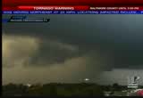
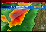
the storm is a rotating. i have not seen any final -- any funnel. i can confirm that is rotatiing. -- rotating. >> we are picking up the change in velocity. there is some wind shear. certainly dangerous. >> we have not gotten any wins just yet. i have not experienced gas higher than 10 miles an hour. it is eerily calm. i do not see that. it is not mixing anything down
6:39 pm

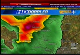
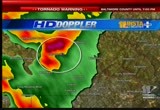
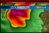
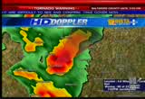
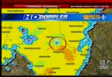
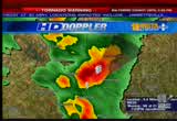
to the service -- circus. there is one little batch of heavy rain. you can see that on the doppler. the low-level clouds, you can see what we call scuds are rotating. whether it forms a funnel or not, it does not matter. take shelter if you are again in the cockneysville area. >> something could kick up pretty quick? >> yes. i wanted you to have a firsthand whlook. >> the rotation is happening, as
6:40 pm
he told us. >> even if we do not have a tornado, you could have a strong a downburst. you can see, we have had an update. the star continues to make its way out to the north and east. what we are worried about as far as potential tournedos -- is it -- it is raining pretty heavy, you are not in the torn natick -- carnatic -- tornadic area. >> we want to remind our viewers. there is a tornado warning until the and -- within the next 19 minutes.
6:41 pm
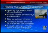
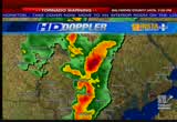
we want you to head to the lowest level of your building. make sure your rooms and doorways are the absolute safest place. please stay away from the windows. we have our witness reports from -- you do not want to take the chance of a gust of wind coming through. cover your head and we urge you strongly to wait for the storm to pass. safety is of the utmost importance. if you are outdoors, crouched down in a low lying areas. the patients -- be patient because this is serious stuff. >> we have the winds analyzed. it shows not only where it is raining but in the direction
6:42 pm
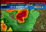
they are moving. part of this storm system, the grain is moving away from the radar, but in others it is moving towards the radar. you can see some sort of develop that happening. right here could be a possible rotation, perhaps a formal -- funnel. there has been no reports of a touchdown, but the warning was released in case of the potential of a storm. if you are out there in the jarretsville area of hartford county, be prepared. not there there will be aced tornado, -- a tornado -- you will see the lightning strikes
6:43 pm
going on. it seems like we are losing some of the energy with the storm. there have been a few little flashes as it approaches cockeysville. we have ehavy downpours and strong winds. >> as we look at the storm, it looks like it is going north on i-95. if you think about the traffic at this time -- i am sure is very slow. >> this is what we are looking at as far as our precipitation and it the wind. >> somewhere in this area is where the possible location is. east of hunters run up near -- this is old york road.
6:44 pm
cooper road -- in this area of baltimore county, moving towards the northeast, that is where we would see the potential of a tornado touched down. no confirmed reports of this yet. that is the way it looks when we look at it on the window display. it looks a whole lot different -- some heavy rain and hail on the northside of a potential funnel cloud. >> this tornado warning what it should at 6:30 and is in effect until 7:00 p.m.
6:45 pm
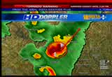
this thing could be in affect for a bit. >> a couple of our employees were had come, they said in a picture -- sent get a picture. this storm looks pretty violent. the leiter shading of heavy rain at downpour's coming out of darker days clouds. this is heavy rain coming down. you can see it rotating around. the lower scud clouds rotating. the darker the cloud, the higher up it is. it is producing a lot of rain. >> as we put these streets in the area that this could exist, we urge our viewers to head to
6:46 pm
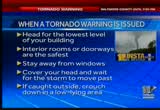
the lowest level that you happen to be in. stay away from the windows and doorways. stay away from any windows. cover your head, and urge you with as much caution to please wait until the storm has passed. this is a fairly quick moving storm, running along at about 25 miles an hour. whatever is happening is not as important -- if someone is caught outside, crouched down in a lower-lying areas. tom here has the computer technology to give you specific areas where we believe it is not only heading, but where this tornado threat may be the greatest.
6:47 pm
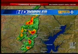
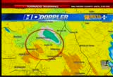
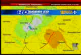
>> here is the latest updates this triangle that goes out from the center of the storm. warnings could be issued up into hartford county this storm cell is rapidly moving toward the baltimore and hartford county line. moving through the carrol mill, into hartford, and into teh jarretsville. hartford county, be rpepared. -- prepared. a storm that could produce a tornado is heading in your direction. we are not seeing as much of a tornado now, and i will check
6:48 pm
the windy here if we are losing any of that. embedded in that rain is the potential for tornadic development. these green-shaded areas are intended to move towards the radar site in virginia, and these orders should areas are moving toward the radar. the general vicinity of old york road -- i believe that is -- the school out of banner road. >> the fact that -- >> st. james school. i have a feeling that is where the center of this is. it will be in that general area.
6:49 pm
>> as these storms have the potential for tornadoes, we have to recognize the potential. the conditions are right for one, but one has not been decided yet. as these storms move, they have a tendency to dissipate over time. i think that lets us ease up a little bit. >> and these are tracking very quickly. it will not be in your neighborhood a very long. the cloud could just skip along and do damage to only treetops. we can see it up in the radar and it is worth warning people about this. it is about to move up into hartford county. this is the wind it display.
6:50 pm

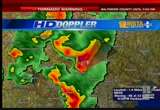
the reign of looks like a bunch of heavy rain. we see different colors indicating the direction of motion. the rain drops appear to be going in one direction and the others appeared to go the other way. right in the st. james area of baltimore county. if it were to touch down, that is where it would be. >> take out the warning for just a second. the heavy rain and wind could cause hazards, particularly if you are out and about. it is a serious tuition no matter how you look at it. >> if the weather service did not issue a tornado warning, they would have issued a severe thunderstorm warning. this storm certainly has potential. >> in the event of a tornado, we
6:51 pm
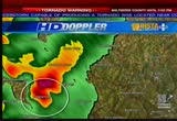
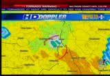
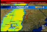
can track the storm anywhere you are. you can try our phone and a ndroid app. you can get the forecast at wbal.com and click on whether -- weather. we are still under this a warning. it is moving rapidly as storms go, moving from a baltimore county and to the hartford county area north east. >> it is moving in that general direction, and i would be taking shelter right now if you are in the jarretsville area. these winds are only 1,000 feet of the ground. the awards shaded areas are
6:52 pm
indicating when it speeds of over 80 miles an hour. these winds are moving rapidly away. there could be some rotation in the general area of of the baltimore and hartford county line. moving off to the northeast at a pretty good clip. if your in this area of northwestern hartford county, take shelter now. the storm cell has strong rotation. it is moving up toward jerry terrell -- jarretsville as we speak. >> there is a possibility for projectiles with these high winds. just the high winds without a tornado can be enough to cause major problems. >> we will get heavy downpours
6:53 pm
-- regardless whether it is a tornado or not, it is a dangerous storm system. >> areas that are prone to flooding, anytime you have a lot of rain coming down, if your area is where you live is prone to flooding, there is always that possibility. >> thankfully, they are moving quickly. hopefully they -- we will not have to talk about flooding. they will not be in the area long enough to produce flooding. the storm is holding together -- the weather service could extend the warning. >> we are -- a tornado warning was issued 25 minutes ago. we were signing off our newscast when we got the word for the next seven minutes or
6:54 pm
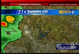
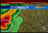
so. the tornado warning may be extended from baltimore county to hartford county. tom is checking -- >> it has been extended it for baltimore to hartford county until 7:30. we will get the updated information and continue to watch this radar. that would be the jarretsville area. take shelter right now in that area of northwestern hartford county. you did not want to risk the possibility of not being ready for it. there are some lightning strikes -- we are seeing it weaken at tie and then gained strength again. old york road here -- this is where the storm is leaving in
6:55 pm
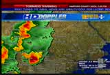
the tracking northeast. leaving the st. james. in baltimore county. it is in the northwestern quarter of hartford county. >> the specific area we are concerned about -- this storm is covering a wide swath. >> there is a line of showers going into the city. it is on the baltimore and hartford county line right now. it is cutting right through hess towards taylor and jarrettsville.
6:56 pm

if something touches down there, we may not know about it since there is a lot of country area. >> the wind in the upper- atmosphere is leading to the combination and a speed and the rotation of the plan. >> there is a lot of wind up there. not all of that is mixed down, as we mentioned, but the fabric can bring that down and it could also tap into some of that air. there are a lot of powerful winds up there. as it taps into the energy up there, it draws a down to the ground level. reaching out into some of that energy that is whipping along in front of us. >> without a tornado touching down, wins to be such that heavy winds can do great damage. that is why we are urging people
6:57 pm
to stay indoors and be patient and let it pass. >> we have a the street lined winds that could damage right along old york -- there is a manner -- manor road. the stores sell is moving in that general direction. dangerous storm system. >> we are trying to get a phone contact, but with stores like this, you cannot make a phone contact because the storm can interrupt signals. we want to get an idea of where the storm is passed and get in touch of us -- with some of our emergency officials. making sure that things are not so bad. making sure that the area in which this is occurring will withstand this warning.
6:58 pm

when eight warning is issued and has been in effect for the past half hour, had it to the lowest level of the building you are in. the anterior wombs or doorways are the absolute safest. -- and interior rooms or doorways are the absolute safest. cause alls' could sorts of problems, so covered your head and stay away from the windows. wait for the storm to move past. tom has all of what we need in terms of technology to let you know where the storm as. we invite you to stay tuned. it is posing a potential problem in a very wide area. if you are caught outside, please crackdown.
6:59 pm
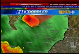
-- crouched down in a slow- flying area. >> this a little pixel indicate some pretty high winds. they are racing in at about one hundred miles an hour a couple hundred feet above the ground. up there in the clouds. this is the bandit -- wind display. theya re moving in the opposite direction. we may have some strong rotation that could at any time drop a tornado. tornado.
268 Views
IN COLLECTIONS
WBAL (NBC) Television Archive
  Television Archive News Search Service
Uploaded by TV Archive on
